
Your Mission Bay reference
Mission Bay Map: Boating, Speed Zones & On-Water Guide.
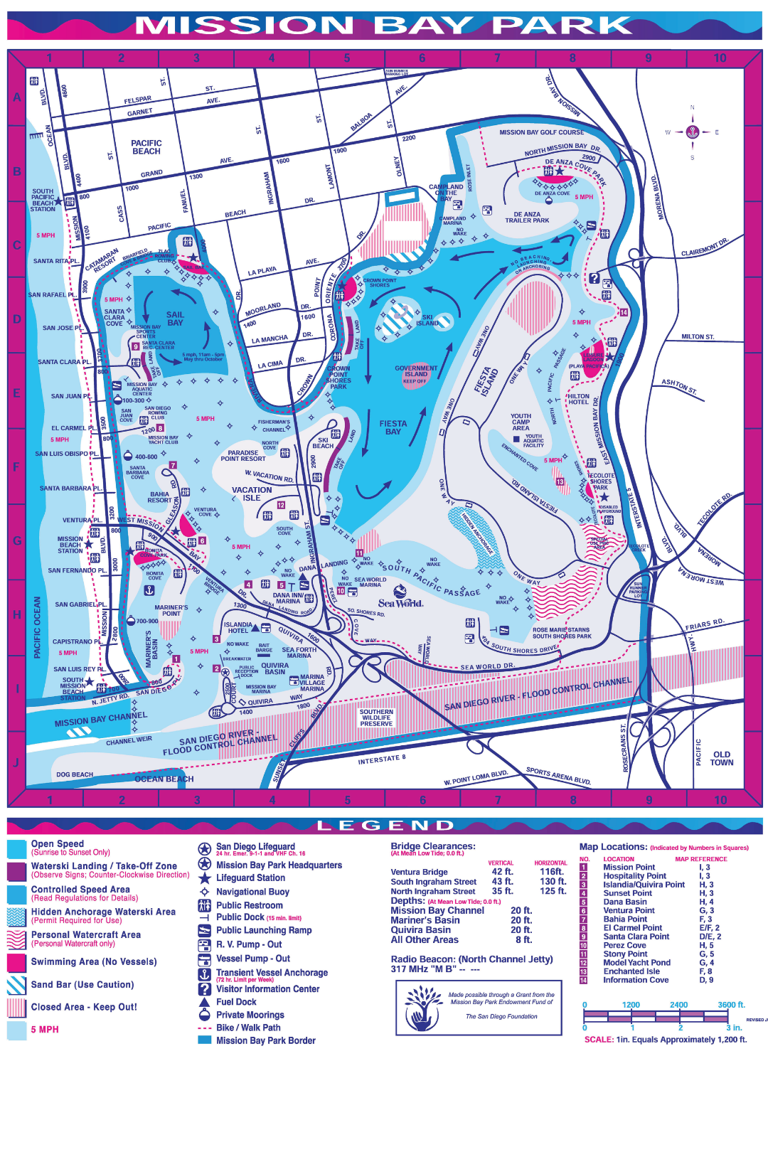
Use this Mission Bay boating map before you launch or keep it open on your phone to identify marked speed areas, swimming and closed zones, personal-watercraft areas, docks and major landmarks. Posted signs, buoys, patrol directions and your dock briefing always control.
Full Mission Bay boating map
Mission Bay areas, landmarks and activity zones.
Use the map to find the six areas in the guide directly below it. Each area explains what to do, what to look for and which Mission Bay Sportcenter rentals typically fit the experience.
Scrollable and zoomable Mission Bay reference map. Use the toolbar buttons to zoom, reset, locate Mission Bay Sportcenter or enter full screen. Mission Bay Sportcenter is marked at Santa Clara Cove near grid D/E–2.
Mission Bay area guide
Things to do and see around Mission Bay.
These ideas help you match the names on the map to real scenery and experiences on the water. They are not automatic route permission. Your equipment, current conditions, posted restrictions and dock briefing determine where you may go.
Santa Clara Cove & Sail Bay
Best fit: Kayak, paddleboard, Hobie catamaran or sailboat
- Do: Start with an easy paddle, practice sailing skills or make a relaxed loop close to the MBSC launch.
- See: Santa Clara Point, sailboats, the sandy Sail Bay shoreline and the Catamaran Resort waterfront.
Watch the seasonal speed markings and remain outside every designated swimming area.
Crown Point & North Bay
Best fit: Pontoon boat
- Do: Take a relaxed sightseeing cruise, follow the shoreline from a safe distance and capture wide group photos.
- See: Crown Point Shores, northern bay views and coastal birds near the Kendall-Frost Marsh shoreline.
This is a longer outing. Keep clear of protected habitat and marked swimming water.
Vacation Isle & Ski Beach
Best fit: Pontoon boat or ski boat
- Do: Cruise through the center of the bay and watch the boating activity around Ski Beach from the water.
- See: Vacation Isle, Ski Beach, the Paradise Point shoreline and boats moving between the central basins.
Ski Beach is not a swimming area. Bridge authorization may be required. MBSC rentals may not anchor, and pontoons or ski boats may not beach.
Fiesta Bay & Fiesta Island
Best fit: WaveRunner, ski boat or pontoon boat
- Do: Enjoy a group cruise or use an authorized daytime riding area when your equipment briefing and current controls allow it.
- See: Fiesta Island, active watersports and some of Mission Bay’s broadest open-water views.
Transit speed limits still apply. Temporary events, including Bayfair, can control movement or restrict entry.
De Anza Cove & East Bay
Best fit: Pontoon boat
- Do: Take a longer scenic cruise and explore the quieter northern end of Mission Bay from outside marked swim areas.
- See: De Anza Cove, Tecolote Shores, waterfront parkland and the broad eastern shoreline.
Confirm that your rental time and manager-approved route allow this distance before leaving the dock.
South Shores & SeaWorld
Best fit: Pontoon boat or ski boat
- Do: Make a longer sightseeing loop through the southern and central bay when your approved route allows it.
- See: South Shores Park, the SeaWorld skyline, Fiesta Island and wide views across the central bay.
Stay clear of launch traffic, posted special-use zones and all designated swimming areas.
If you are unsure on the water
Slow down. Look around. Get the right help.
Use this three-step reset.
If the shoreline, signs or zone markings do not match what you expected, do not guess or continue at speed.
On-water emergency
For immediate danger, call 911.
If a marine VHF radio is available and you are in grave and imminent danger, use Channel 16 and say “MAYDAY” three times. Identify the vessel, give your position, nature of distress, assistance needed, number aboard and vessel description.
If it is safe to do so, also contact Mission Bay Sportcenter. Do not delay emergency services to call the dock.
Read the map in 30 seconds
The Mission Bay map key.
Color is only one cue. Each card repeats the map meaning in text so the guide stays understandable in bright sun, on small screens and with assistive technology.
Open-speed area
Open speed is permitted only from sunrise to sunset. Posted, distance, event and patrol restrictions still apply.
5 mph area
Operate at 5 mph or less. Look for map labels and current posted markers because limits vary by place and time.
Swimming area
No vessels. Stay completely outside designated swim areas and keep required distance from swimmers and beaches.
Personal-watercraft area
Special-use area for personal watercraft. Use only when your equipment and current instructions authorize it.
Closed area
Keep out. Temporary closures and special events can also create controlled areas that are not printed on this map.
Waterski takeoff / landing
Reserved for active waterski participants. Observe posted signs, permitted uses and directional requirements.
Sand bar
Use caution. The static map does not provide live depth, tide, hazard or clearance information.
Controlled-speed area
Read current regulations and posted signs for the applicable operating limit before proceeding.
Selected City boating rules
Know when 5 mph is the maximum.
This is a quick-reference summary, not the complete law. Current City rules, posted markers and official instructions control.
Mission Bay Sportcenter rental boundaries
The map shows the bay. Your briefing defines the rental.
MBSC rental rules can be stricter than general City permissions. Follow the equipment-specific route and operating instructions given at check-in.
Remain inside Mission Bay
Do not enter the Mission Bay jetty or inlet leading to the ocean, and do not enter the ocean. Follow the turnaround point identified during your equipment-specific dock briefing.
Stay out of swim and closed zones
Do not enter designated swimming areas, closed areas or temporary regulated zones. Current barriers and official directions take priority over the printed map.
Do not anchor or beach rentals
No Mission Bay Sportcenter rental may be anchored. Pontoons, ski boats and WaveRunners may not be beached. Return to the MBSC waterfront as instructed.
No towing
Do not tow tubes, skiers, wakeboarders or any other person or device behind a Mission Bay Sportcenter rental.
Confirm bridge routes
Printed clearances are not route permission. Do not pass under any bridge unless an MBSC manager expressly authorizes that route for your specific rental.
Launch and rotate at MBSC
WaveRunner riders and drivers must depart from and return to the MBSC waterfront. Driver changes happen at the dock after applicable waiver and safety requirements.
Choose how to explore
Turn the map into a Mission Bay day.
Choose the pace that fits your group, review the equipment-specific details and use the live booking calendar for current rates and start times.
Jet Skis
High-energy Yamaha WaveRunner riding with required preparation and a dock-to-riding-area route briefing.
Power Boats
Keep a group together on a pontoon or choose a sportier private ski-boat experience inside Mission Bay.
Paddle
Launch a single or tandem kayak, or choose an active stand-up paddleboard session from the waterfront.
Sail
Compare Capri, Catalina and Hobie options for a wind-powered Mission Bay experience.
Mission Bay map FAQ
Quick answers before you launch.
Where are the 5 mph zones in Mission Bay?
Mission Bay is limited to 5 mph from sunset to sunrise. During daylight, 5 mph also applies where buoys are posted, near bridges, within 100 feet of shore, within 100 feet of another vessel, within 100 feet of a swimmer or surfer and within 200 feet of a beach used by swimmers. Read current signs and the City’s complete rules.
Where can Jet Skis go fast in Mission Bay?
Operate at speed only in a designated area authorized for your rental and current conditions. Open-speed markings do not cancel distance limits, posted restrictions, seasonal limits or temporary event controls. Follow the exact route and operating-area briefing given at the MBSC dock.
Can Mission Bay Sportcenter rentals enter the ocean?
No. All standard Mission Bay Sportcenter rentals must remain inside Mission Bay and may not enter the Mission Bay jetty or inlet leading to the ocean or enter the ocean itself.
Can I beach or anchor an MBSC rental?
No Mission Bay Sportcenter rental may be anchored. Pontoons, ski boats and WaveRunners may not be beached. Follow the return and docking instructions provided for your specific rental.
Can my rental pass under a Mission Bay bridge?
Do not treat printed bridge clearances as route permission. Do not pass under any bridge unless a Mission Bay Sportcenter manager expressly authorizes that route for your specific rental.
Is this a live navigation map?
No. This is a static orientation reference, not GPS or a live nautical chart. It does not show every current hazard, closure, event zone, depth, buoy or sign. Current official information and instructions always control.
How do I save the Mission Bay map to my phone?
Choose “Open Full-Resolution Map,” then use your phone browser’s share or save-image controls. Saving it before departure can help when cellular service is weak, but the static image still does not replace current signs, instructions or live navigation.
Ready for Mission Bay?
Choose the rental. Know the bay.
Compare every Mission Bay Sportcenter rental, check the live calendar, then arrive early for check-in, waivers and the equipment-specific safety briefing.
Questions? Call 858-488-1004